
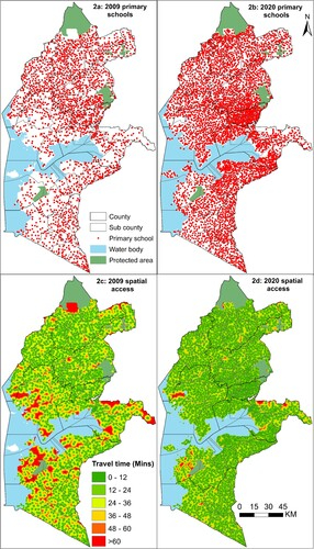
Understanding the location of schools relative to the population they serve is important to contextualise the time students must travel and to define school catchment areas (SCAs) for planning. A master school list is a geo-database of educational, demographic, and socio-economic data for schools to facilitate planning and decision-making usually created through a mapping exercise. Evaluating these databases within a geospatial information system (GIS), decision-makers and stakeholders can plan to rehabilitate or expand existing schools, construct new or merge existing schools guided by the population dynamics or plan for additional teachers and other resources. Defining travel time to school is essential in highlighting areas and school-going children (SGC) who are marginalised and need prioritisation during policy making, resource allocation and distribution. This case study based on research, assembled a spatio-temporal database of public primary schools (PPS), population density of school-going children (SGC), and factors affecting travel in 2009 and 2020 in Kenya. To model travel time to the nearest PPS, this research used the ‘accessibility module’ of AccessMod software, a Digital Public Good (DPG).