Problem Statement
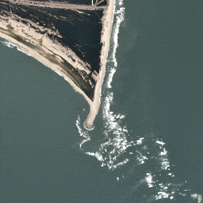
Coastal managers face a complex set of challenges as they balance the demands of environmental conservation, economic development, and community resilience. Rising sea levels and increasing storm intensity due to climate change threaten coastal infrastructure and ecosystems requiring managers to accurately detect and analyze changes. Coastal erosion, habitat loss, and pollution further complicate efforts to maintain the balance between human activity and natural processes. Moreover, the growing pressure from tourism, urbanization, and resource exploitation intensifies the tension between short-term economic gains and long-term sustainability.
How EO Can Help
Satellite technologies combined with in situ monitoring which provides the necessary local context, verification, and additional details , provide an efficient and scalable means of monitoring coastal areas, leveraging satellite-based data to deliver actionable insights. Optical and radar imagery are used to track shoreline changes and assess flood-prone areas. Altimetry and bathymetric data enhance understanding of sea-level trends and storm surge risks, while multi-temporal imagery provides insights into long-term erosion patterns. In this sense, EO supports both localized risk assessments and broad-scale monitoring, empowering stakeholders to identify vulnerabilities, prioritize interventions, and adapt to climate-driven changes.
- Tracking Coastal Dynamics and Erosion: Understanding shoreline movement and erosion patterns is critical for protecting coastal infrastructure and ecosystems. EO enabled technologies offer consistent, detailed monitoring of these changes over time, enabling data-driven decisions. For example, optical imagery is widely used to track shoreline positions and detect movement patterns though it may be obscured by cloud cover and in situ monitoring, such as GPS-based coastal surveys or beach profiling, can fill in gaps and verify satellite-derived data. By analyzing multi-temporal datasets, authorities can detect erosion hotspots and areas of accretion. For regions with persistent cloud cover or nighttime conditions, Synthetic Aperture Radar (SAR) data offers a reliable alternative for uninterrupted monitoring. High-resolution imagery also aids in understanding sediment transport and deposition patterns, essential for studying coastal geomorphology. Additionally, Digital Elevation Models (DEMs) provide valuable insights into topographical changes contributing to erosion risks, though accuracy can be limited in steep or vegetated coastal regions. Satellite overpasses may not frequently enough capture certain dynamic processes, such as tidal effects or diel vertical migrations of harmful algal blooms, necessitating a combination of data sources.
- Assessing Flood Risks: EO solutions play a vital role in monitoring sea level changes and assessing flood risks associated with storm surges and extreme weather events. Satellite altimetry provides precise measurements of long-term sea level trends. High-resolution bathymetry data complements altimetry, allowing for a better understanding of localized flooding risks and in situ monitoring with tide gauges and local flood sensors provide up to date data that ensures satellite predictions align with actual conditions. By combining altimetry with SAR imagery, EO enables the mapping of inundation areas during extreme environmental events, providing insights for resilience. Optical data is instrumental in delineating flood-affected regions post-event, guiding emergency response and recovery efforts. However, the coarse spatial resolution of altimetry data limits its effectiveness for localized analyses.
- Monitoring Coastal Habitats: Additionally, EO is invaluable for the conservation and management of coastal habitats such as mangroves, wetlands, and coral reefs. Optical imagery captures the health and spatial extent of vegetation in mangroves and wetlands, supporting habitat monitoring and restoration planning. Multi-spectral imagery further enhances the ability to monitor coral reef conditions, including the detection of bleaching events that indicate ecological stress. Through multi-temporal analysis, EO enables the identification of habitat loss or degradation, guiding targeted conservation actions. SAR complements optical data by providing insights into vegetation structure, offering a detailed view of mangrove forest health and dynamics. Ground based monitoring, such as water quality sampling and direct coral assessments, are also essential for verifying EO data and identifying subtle ecological changes, enhancing conservation and restoration efforts. Despite these capabilities, differentiating between habitat types often requires high-resolution or hyperspectral data, which may be costly or unavailable for some regions.
Economic Impacts | Environmental Impacts |
Early detection of erosion and flood risks reduces the need for expensive emergency repairs, extending the life expectancy of coastal infrastructure. | Detecting changes in vegetation or water quality helps to identify threats like deforestation, overfishing, or coral bleaching. This precise monitoring is vital for promoting biodiversity. |
Risk maps enable governments to allocate funds efficiently, prioritizing high-risk areas for protective measures like seawalls or mangroves. | Mangroves and other coastal ecosystems are highly effective carbon sinks. Monitoring their extent with EO ensures that their capacity to sequester carbon is preserved and expanded. Moreover, by promoting conservation and avoiding habitat destruction, EO helps limit carbon dioxide and methane releases from degraded or deforested areas. |
Protecting coastal ecosystems sustains industries like fisheries and tourism, contributing ~US $30 billion annually (Chen et al. 2015). | EO technologies like multispectral imaging detect sediment plumes, algal blooms, and chemical pollutants in nearshore waters, enabling faster interventions to improve water quality. Cleaner water benefits marine species that rely on clear, oxygen-rich environments, from fish to shellfish to corals. |
EO reduces the financial losses from storm surges and floods by enabling proactive measures, saving billions in disaster recovery costs. | EO reduces disturbances to fragile ecosystems. For example, aerial and satellite imagery eliminates the need for boats or on-foot inspections in sensitive areas. Minimizing human presence prevents unintended impacts on wildlife, such as stress or habitat disruption in breeding or feeding zones. |
Case Study: NOAA CoastWatch's Satellite-Powered Environmental Monitoring
NOAA CoastWatch leverages EO data from satellites to support comprehensive monitoring and management of U.S. coastal and marine environments. By analyzing satellite imagery and data, NOAA tracks key coastal conditions, such as sea surface temperatures, chlorophyll concentrations, and ocean currents, to detect early warning signs of environmental changes. One critical application is monitoring harmful algal blooms, which can have economic and environmental consequences, including fish kills, impacts on public health, and disruptions to local economies dependent on fishing and tourism. Additionally, EO data is used to assess coastal erosion and habitat changes, providing valuable insights for managing these dynamic environments. In fisheries management, NOAA utilizes EO to monitor the distribution and abundance of key fish species, improving the sustainability of these resources. The data aids in the development of more accurate models for managing fish stocks, helping to prevent overfishing and ensure long-term sustainability. By providing timely data, NOAA CoastWatch enhances the ability of stakeholders to respond to environmental threats promptly, ultimately improving coastal resilience and protecting vital resources.
Case Study: Combating Sargassum Horneri with EO
Sargassum horneri is a rapidly spreading brown macroalgae that has caused millions in aquaculture loses and severe disruptions to Korea’s fisheries and tourism since 2015. To combat this growing issue, TelePIX, in partnership with the Korea Institutes of Ocean Science and Technology (KIOST), leveraged Chollian-2B data to develop an advanced detection algorithm for floating algae.
Chollian-2B, the world’s first geostationary environmental monitoring and oceanographic satellite, builds on the success of its predecessor, Chollian-1 (COMS), by delivering high-frequency, high resolution data on marine and atmospheric conditions. Equipped with GOCI-II, an advanced ocean monitoring payload, the satellite provides critical insights into marine ecosystem changes, including harmful algal blooms like Sargassum horneri.
This led to the development of PiXative, an AI-powered ocean science big data platform that integrates satellite observations from Chollian, Landsat and Sentinel. PiXative tracks and maps marine debris and algae blooms to deliver automated daily analysis reports and near real-time alerts when Sargassum horneri approaches key coastal areas. Beyond mitigating economic and environmental damage, these insights help quantify the role of marine ecosystems in global carbon capture. This bridges the gap between local conservation efforts and global climate strategies.