Problem Statement
In the agricultural sector, achieving optimal crop yields while minimizing costs is a challenge every farmer faces. Without accurate and timely information about plant health, water, and soil conditions, farmers often resort to inefficient practices such as over-irrigation and excessive use of fertilizers. These inefficiencies not only lead to reduced crop yields but also increase operational costs while contributing to environmental issues such as water wastage and chemical runoff, which can degrade soil quality and harm aquatic ecosystems. These challenges are increasingly amplified by climate change, conflict, and economic instability and can directly threaten global food security.
How EO Can Help
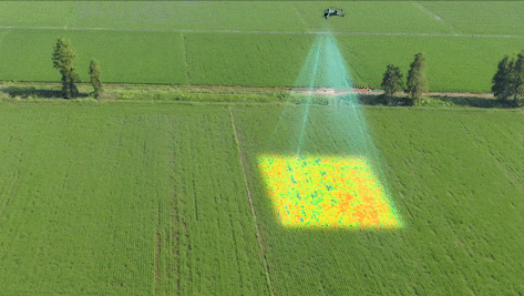
Earth observation (EO) technologies offer an efficient way to optimize crop yield, manage irrigation, and identify pest outbreaks by using a combination of remote sensing tools and data analytics to monitor and manage agricultural fields at scale. One significant application of EO technologies is monitoring crop health, particularly in detecting plant stress and ensuring optimal growth. By using sensors on satellites or drones to capture data in visible, near-infrared (NIR), and short-wave infrared (SWIR) spectra, farmers can identify areas of crop stress caused by nutrient deficiencies, water scarcity, or disease. These insights directly contribute to better crop yield area estimates and more accurate production forecasts, enabling decision-makers to anticipate potential production shortfalls and implement proactive interventions.
- Manage Nutrients: EO technologies play a crucial role in precision nutrient management, optimizing fertilizer application to enhance crop productivity. Sensors measure spectral signatures related to chlorophyll content and plant health, providing data that, when integrated with soil sampling and on-ground sensors, helps farmers create nutrient management zones. This precise application of fertilizers ensures that crops receive the right amounts of phosphorus (P), potassium (K), and magnesium (Mg), improving nutrient efficiency and reducing waste.
- Manage Irrigation Efficiently: Efficient irrigation management is another critical area where EO technologies make a significant impact. Thermal sensors detect temperature variations in the crop canopy, indicating water stress levels. Additionally, satellites like NASA’s Soil Moisture Active Passive (SMAP) mission measure soil moisture levels. This can be combined with on-ground soil sensors that measure specific parameters like soil moisture, temperature, pH, and electrical conductivity. These sensors help identify areas where irrigation is needed by detecting cooler (well-irrigated) and warmer (water-stressed) zones.
- Analyze Soil Texture and Structure: Light Detection and Ranging (LiDAR) can be used to map terrain and analyze soil depth and structure. This can be paired with ground-penetrating radar (GPR) and lidar to analyze soil structure and texture. The reflection of radar waves provides information about clay and silt composition, which helps determine the water-holding capacity of different zones. This data informs the frequency and amount of irrigation needed for different soil types. This information is critical for understanding soil structure, drainage, and how well crops will root and grow in specific zones.
- Identify Pest Outbreaks: This technology detects subtle changes in plant physiology caused by early pest infestations. Hyperspectral sensors capture hundreds of bands of data, making it possible to detect shifts in chlorophyll content and other plant biochemicals, which may indicate pest activity even before visible symptoms occur. Using machine learning algorithms, organizations can analyze multispectral and hyperspectral data over time to identify anomalies in crop health that might be indicative of pest outbreaks. Early detection enables more targeted pesticide use, minimizing both costs and environmental impact.
Through predictive capabilities and early identification of potential issues including production shortfalls, EO technologies not only improve operational efficiency but also facilitate proactive interventions to address emerging agricultural challenges.
Economic Impacts | Environmental Impacts |
Increases crop yields by up to 2.5% for certain crops through improved pest and disease management and variable rate application (VRA). | Reduces water usage by up to 25% and energy usage required for irrigation, further decreasing GHG emissions. |
Lowers operational expenses by as much as 25% when applying fertilizers and water more efficiently. | Facilitates the use of techniques like no-till that minimize soil disruption and can increase soil organic carbon stocks by 8%. |
Increases farm profitability by up to USD 50 per acre, depending on the crop and region. | Enhances soil health (indexed with the selected soil physiochemical and biological properties) by 45%. |
Improves market transparency, stabilizing food prices and reducing the risk of speculation and volatility. | Reduces excess water and chemicals that can runoff into nearby water bodies. |
Supports efficient allocation of resources for agricultural planning and food aid mobilization through more accurate production estimates. | Abates GHG emissions from nitrous oxide (N2O) by 39% which has 273 times the warming potential of CO2 by mass. |
Case Study: Supporting Food Security During the Ukraine Conflict
During the conflict in Ukraine, the Group on Earth Observations Global Agricultural Monitoring Initiative (GEOGLAM) provided timely updates on crop production losses and abandoned croplands, enabling international organizations to plan timely food aid and manage market speculation, ultimately stabilizing food prices and ensuring resource allocation where it was needed most. One significant finding was the abandonment of approximately 7% of Ukraine's cropland due to direct damage from fighting, landmines, and the displacement of farmers, particularly in the eastern and southern regions. Despite these challenges, Ukraine’s wheat production in 2022 reached an estimated 26.6 million tons, higher than initially expected, thanks to effective coordination, resilience, and the use of EO data to support timely interventions. However, the abandonment of cropland and loss of irrigation contributed to a decrease in overall agricultural productivity, reducing production by approximately 5 to 7 million tons compared to pre-war levels.
A subsequent major blow came from the collapse of the Kakhovka Dam on June 6, 2023, causing widespread flooding and the loss of critical irrigation infrastructure in southern Ukraine. This event further strained agricultural production by inundating farmland and disrupting water supplies essential for crop cultivation. Throughout these crises, GEOGLAM partners' use of EO data played a pivotal role in monitoring agricultural production, providing accurate assessments that helped mitigate speculation and stabilize global food markets. Additionally, EO technologies enabled the identification of unexploded ordnance in agricultural fields, ensuring safer farming practices and facilitating the planning of timely food aid and recovery efforts in the wake of the dam collapse and widespread displacement. This initiative exemplifies the power of public-private partnerships in leveraging Earth observation for agricultural sustainability and food security.
This use case was created with contributions from ClimateAI and Group on Earth Observations.