Network Condition Monitoring
Problem Statement
The maintenance and operational efficiency of large-scale energy infrastructure, such as power lines and solar plants, are critical for ensuring reliable energy distribution and generation. These infrastructures are constantly exposed to environmental hazards like land subsidence, vegetation encroachment, and other natural or anthropogenic changes, which can compromise their structural integrity and functionality. Traditional monitoring methods are often costly, time-consuming, and may not provide timely data to prevent or mitigate risks effectively.
How EO Helps
Earth observation (EO) technologies provide a robust framework for monitoring and analyzing the condition of energy infrastructure, such as power lines, across large and remote areas. Unlike traditional ground-based methods, EO enables continuous monitoring and up to date alerts, allowing operators to identify and respond to emerging risks more effectively. By leveraging advanced sensors, high-resolution imagery, and data analytics, EO helps ensures a proactive approach to maintaining network health and mitigating potential disruptions.
- Vegetation Identification: Light Detection and Ranging (LiDAR) and high-resolution optical imagery, enable large scale mapping and monitoring of vegetation encroachment on critical infrastructure. This capability is particularly valuable for power, where overgrowth can cause service interruptions or damage. Traditional manual vegetation inspection is time-consuming and can miss early warning signs. EO provides actionable insights to prevent interruptions, reduce maintenance costs and enhance operational efficiency.
- Subsidence Detection: Advanced sensors like Synthetic Aperture Radar (SAR) detect even minor ground movement that could compromise the stability of structures. Traditional subsidence monitoring methods, such as localized ground surveys and borehole measurements, are often insufficient for identifying widespread or subtle subsidence. EO delivers high-resolution, wide-area detection, enabling early warnings and timely interventions to avoid structural damage or service disruptions.
- Damage Assessment and Recovery Planning: High-resolution imagery and SAR data allow for rapid post-event damage assessments following natural disasters such as storms, floods or earthquakes by providing a comprehensive view of affected infrastructure. This enables operators to prioritize repairs, deploy resources efficiently, and restore services faster all of which minimizes downtime and reduces costs associated with delayed recovery efforts.
Economic Impacts | Environmental Impacts |
Continuous monitoring and vegetation management reduces the need for frequent manual inspections, lowering operational costs by up to 50%. | EO aids in the early detection of environmental hazards, such as vegetation encroachment and subsidence, which helps prevent wildfires. Preventing wildfires greatly limits the amount of CO2 released from combustion, with an estimated GHG reduction of 64 million tonnes by 2030. |
Proactive maintenance strategies ensure quicker responses to infrastructure issues avoiding costly service disruptions. |
|
Case Study: AI-Driven Vegetation Management for Utility Circuits
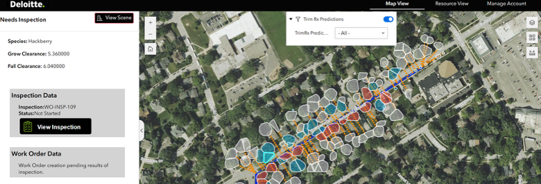
Deloitte's AI-driven vegetation management solution leverages advanced remote sensing data, including classified ortho or stereo Digital Surface Models (DSMs) and LiDAR imagery, to transform labor-intensive utility inspections into a more efficient, cost effective, and scalable process. Today, many power utilities manually inspect all trees near circuits on a cyclical time based process, requiring significant time and resources and prone to human subjectivity error.
Using photogrammetry techniques, Deloitte’s solution is designed to generate precise 3D digital models of both vegetation and infrastructure, which are then analyzed by predictive AI algorithms. These digital models and algorithms work together to identify precise vegetation clearances, risk prioritize trim/removal work for the current cycle period and forecast growth all at an individual tree basis to predict future maintenance all of which enable effective & proactive management. Continuous refreshes of remote sensing data provides the foundation for the AI analysis, replacing traditional methods with precise, scalable insights.
By integrating remote sensing data and AI models, utilities can automate 30-50% of the trim and removal work identification process and consequently reducing reliance on manual efforts and increase the level of work precision. This can leads to potential benefits such as : 1) operational efficiency and O&M reduction 2) reliability increases from less vegetation caused outages 3) safer communities (wildfire ignition prevention) and 4) optimized field worker time.