Problem Statement:
Urban areas are experiencing rapid growth, often leading to unplanned development, inadequate infrastructure, and environmental degradation. Planners face challenges in managing land use, monitoring infrastructure expansion, and addressing issues such as urban heat islands, urban droughts, flooding, and air pollution. Urban planning tools rely heavily on outdated or incomplete data, limiting the ability to make timely and informed decisions. Without accurate data on the urban environment, this combination of challenges exacerbates the risk exposure of urban populations.
How EO Can Help:
Earth observation (EO) technologies offer vital solutions that can transform urban planning practices by providing precise and actionable information to cities:
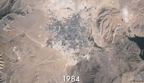
- Monitoring Land Use and Urban Growth: EO provides critical insights into land use changes, enabling planners to track urban growth and manage resources effectively. High-resolution optical imagery from Sentinel-2 and Landsat is instrumental in monitoring the spatial expansion of cities, detecting informal settlements, and identifying encroachments on green spaces or agricultural lands. Multi-spectral analysis supports land use classification, distinguishing residential, commercial, industrial, and green areas, which informs zoning decisions and urban development plans. However, differentiating specific land use types in dense urban areas often requires very high-resolution commercial imagery from providers like Planet or Maxar, which increases costs. Integration with cadastral (land ownership) data is also necessary for effective zoning, but such data may be incomplete in many regions, posing additional challenges.
- Monitoring Environmental Impacts: EO supports environmental monitoring in urban areas, addressing challenges such as air pollution, flooding, and urban heat islands. Thermal imagery from MODIS or Sentinel-3 identifies urban heat islands, helping planners target areas for cooling interventions like tree planting or reflective roofing. High-resolution thermal sensors such as ECOSTRESS provide granular insights into temperature variations at the neighborhood level, even higher-resolution commercial data from providers like Constellr can be used for daily monitoring at individual building level. Flood risks are assessed using SAR data from Sentinel-1, which monitors impervious surface expansion and maps flood-prone areas, even during heavy rain or cloudy conditions. This data, when integrated with Digital Elevation Models (e.g., SRTM or ASTER), enhances flood risk mapping. Air quality monitoring is supported by satellite-derived indices from Sentinel-5P, providing regional-scale data on pollutants like NO2 and SO2, which highlight areas needing targeted interventions. However, thermal data may lack the resolution needed for hyper-local planning, and air quality monitoring often requires integration with ground sensors to ensure accuracy.
- Optimize Urban Heat Resilience and Cooling Strategies: EO enables planning, monitoring and validating heat resilience measures and thus optimize cooling strategies. The impact of urban green, rainwater harvesting and land cover management for reducing heat islands can be continuously optimized by regularly using land surface temperature (LST) measurements at high spatial and temporal resolution. Using LST from Landsat as a historical baseline, LST from providers like Constellr can be employed to constantly assess the cooling power, health and water availability of urban greens, identify hot spots and cooling potential at hyper local level and thus optimize resource usage for climate resilience measures in any city worldwide.
- Optimizing Infrastructure Development: EO aids in planning and monitoring urban infrastructure, ensuring efficient resource allocation and compliance with sustainability goals. Optical and radar imagery are used to map roads, railways, and other transport infrastructure, highlighting connectivity gaps. Nighttime lights data from sources like VIIRS provides insights into urban activity patterns, supporting transit-oriented development. EO also supports green infrastructure planning by helping planners identify areas for green spaces, assess tree canopy cover, and monitor vegetation changes using indices like NDVI (Normalized Difference Vegetation Index) from Sentinel-2. High-resolution imagery is instrumental in identifying unauthorized constructions and ensuring compliance with building codes and zoning regulations. However, keeping infrastructure data relevant requires frequent updates, particularly in rapidly growing cities. High-resolution commercial imagery is often required for detailed monitoring, adding to the overall costs of urban infrastructure planning.
Economic Impacts | Environmental Impacts |
Satellite data could replace or augment ground surveys, leading to substantial cost savings in urban projects. | Thermal imaging from EO satellites identifies urban heat islands, enabling targeted interventions such as increasing vegetation or modifying building materials. These measures can lead to temperature reductions of up to 2 degrees celsius in affected areas, improving urban livability and reducing energy consumption for air conditioning. |
Access to accurate, up-to-date EO data enables more efficient infrastructure development. This precision reduces the likelihood of costly planning errors and resource misallocation, optimizing long-term investments for governments and developers. | EO technologies provide data on air and water quality, allowing for the identification of pollution sources and the assessment of mitigation strategies. For example, satellite observations have been used to monitor nitrogen dioxide levels, informing policies that have led to measurable decreases in urban air pollution. |
Implementing EO-driven urban planning can lead to improved environmental quality and infrastructure, which in turn enhances property values. | By detecting unauthorized deforestation or encroachment on protected areas, EO supports conservation efforts and sustainable resource management. |
Case Study: Leveraging High-Resolution Thermal Data for Climate Resilient Urban Development
In India, urban sprawl has amplified the effect of climate change when it comes to urban heat. New, climate resilient cooling strategies will need to be established to alleviate the heat issue.
Constellr, a global provider of high-resolution thermal data, has been working with Dhun Life, using thermal data to validate their approach to sustainable urban development: Applying only nature-based solutions to change the land cover like planting trees and rainwater harvesting, the area of Dhun was cooled down by 7°C over the span of 9 years compared to an established residential area of nearby Jaipur City. Thus, the development and planning measures in Dhun are more than validated, establishing a blueprint for climate resilient planning.
As urban development continuous, regular monitoring using high-resolution thermal data will allow for directly optimizing resource use towards heat management, increasing productivity and reducing health and environmental impacts.