Problem Statement
Wildfires, worsened by climate change, causes extensive damage to infrastructure, ecosystems, and communities. In 2023 many regions experienced record-breaking wildfire activity, with a global total of over 55 thousand wildfires which generated approximately 2,170 megatonnes of carbon emissions. Managing these wildfires, and minimizing the damage they cause, is imperative and involves preparation, timely response, and post-event assessment. Monitoring conditions for prescribed burns, detecting and tracking active fires, and assessing damage are all critical for mitigating impact. Traditional damage assessment is often slow and risky, highlighting the need for timely updates on affected structures, land, and vegetation to prioritize response efforts and allocate resources efficiently.
How EO Can Help
Earth observation (EO) technologies offer essential tools for wildfire management, supporting land managers, responders, and environmental agencies. Traditionally methods, relying on ground observations and delayed data, limit decision-making speed and accuracy. EO offers more comprehensive and up to date insights through continuous monitoring, large-scale coverage, and precise data on vegetation, weather and fire behavior. Although satellites face some limitations in detecting fires, such as difficulty detecting small or low-intensity fires and cloud cover limiting observation, as satellites continue to advance detection times are becoming much shorter. Currently, for the continental US, active fire data is available within one hour of satellite observation or even within one minute using direct broadcast data and software developed by University of Wisconsin-Madison’s Space Science and Engineering Center.
- Preparing for Prescribed Burns and Risk Assessment: EO data helps prevent uncontrolled wildfires by identifying areas suitable for controlled burns. Vegetation indices, like the Normalized Difference Vegetation Index (NDVI) from MODIS or Sentinel-2 highlight regions with dry or dense vegetation, while tools like Landsat Thermal Infrared Sensor (TIRS) pinpoints hotspots suitable for fuel reduction. Moreover, EO data provides accurate mapping of areas where controlled burns have been conducted, ensuring compliance and minimizing the risk of overlap with vulnerable ecosystems. By reducing fuel loads strategically, land managers lower wildfire intensity and risk, protecting both communities and ecosystems.
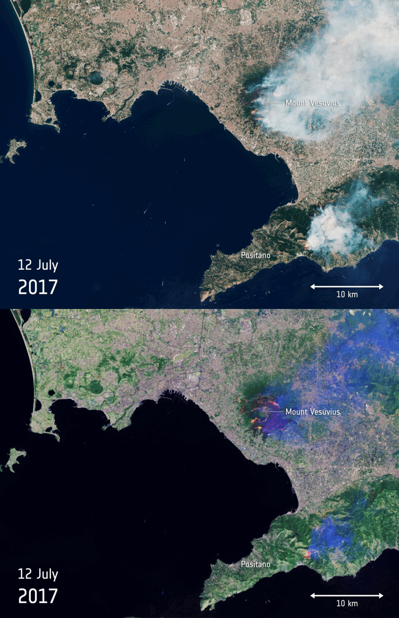
- Tracking Active Fires for Emergency Response: EO technologies continuously monitor certain areas allowing fires to be detected early on and they provide critical, timely data during wildfires, helping responders track fire spread, intensity, and direction. Satellites detect hotspots, guide firefighting efforts, and monitor smoke plumes for public health alerts. UAVs deliver high-resolution images and thermal data in hard-to-reach areas. This accurate, up-to-date information enables responders to deploy resources effectively, protect lives, and minimize property damage.
- Assessing Damage and Supporting Ecosystem Recovery: EO data accelerates post-wildfire recovery by quickly mapping damage, erosion risks, and ecosystem recovery. Satellites like Landsat and Sentinel-2 use indices like Burned Area Index (BAI) and the Normalized Burn Ratio (NBR) to quantify burned areas, while vegetation indices like NDVI track regrowth. High-resolution imagery identifies erosion-prone areas, guiding reforestation and soil stabilization efforts, all without requiring hazardous field assessments.
Economic Impacts | Environmental Impacts |
Early detection of wildfires reduces the area of land affected, potentially saving lives and property. | Preventing or extinguishing fires before they spread can greatly limit the amount of CO2 released from combustion, with an estimated GHG reduction of 64 million tonnes by 2030. |
Access to timely EO data helps emergency responders deploy resources more efficiently, reducing emergency response costs. | Accurate monitoring enables targeted firefighting efforts, helping to minimize erosion, maintain soil structure, and preserve water quality. This approach also protects biodiversity and wildlife. For example, during Australia’s 2020 fires, an estimated 3 billion animals were harmed. |
Mapping burn areas and prioritizing high-risk sites reduces costs associated with post-wildfire restoration projects. |
|
Case Study: Enhancing Fire Detection in the Amazon with NASA's New Algorithm
NASA is working to improve the detection of understory fires in the Amazon rainforest, where dense canopy and low-intensity blazes often make detection from space challenging. These fires, while small, can have a devastating impact on the ecosystem, killing up to 50% of trees in affected areas. Dr. Shane Coffield, a researcher at NASA’s Goddard Space Flight Center, has developed a refined fire detection algorithm to address this issue, building on the existing system used by NASA’s Suomi NPP and NOAA-20 satellites. The current system, using the Visible Infrared Imaging Radiometer Suite (VIIRS), is effective for detecting larger fires but struggles with small, hidden fires in the Amazon. These fires, often obscured by the thick tree canopy or smoke, emit minimal thermal radiation, which can lead to underreporting. Coffield’s modification lowers the detection thresholds to capture these smaller, harder-to-see fires, improving detection accuracy in this unique environment. To further enhance detection, Coffield integrates higher-resolution data from Landsat 8, Landsat 9, and Sentinel-2 satellites, which provide more detailed imagery than VIIRS. While these satellites offer 30-meter resolution, they have a lower revisit frequency—available only every two to three days, compared to VIIRS’s twice-daily observations. Coffield is also exploring the use of machine learning to identify warm pixels near known fire hotspots, helping to detect smoldering fires hidden by smoke or trees. This refined detection system is already being applied in the Amazon, providing better tools for forest management and conservation. By leveraging satellite technology and advanced algorithms, NASA is improving fire monitoring in the region, offering valuable insights to mitigate the environmental impacts of these fires.
This use case was created with contributions from Chipsafer and the National Aeronautics and Space Administration.